Wednesday, April 25, 2012
Lab 3: Neogeography
View Life in Boyle Heights in a larger map
I have lived in Boyle Heights, California, in the Los Angeles County, for my entire life. Although I started living on campus this year, I visit my hometown often and frequently visit the areas marked on this map. These places have given me many memories and continue to do so and because of neogeography, I am able to mark and show these places on a map with much ease. Neogeography gives everyone the chance to be a geographer. People are able to make their own maps and share them with whomever they choose. Neogeography allows users to describe places to others in an astonishing way. It allows people to digitally update information and add multimedia; embedding links, photos, and videos to the places they want within these maps to make the experience of the place much more real. In addition, marking online maps though neogeography as opposed to marking on paper maps is a cleaner, easier, and more attainable process. It is more environmentally friendly, saving paper and thus having the potential to limit deforestation. Neogeography is a cooperative effort of people from all over the world and therefore has the potential to contribute significantly to our knowledge and understanding of the world and the societies in it. The information shared and followed by various people can be used to help in everyday life.
However, while neogeography does have the potential to help us gain knowledge, it also has the power to lessen it. Sadly, not all people are honest, and even those who are make mistakes sometimes. Neogeography is relatable to Wikipedia. It gives access to anyone with Internet to create a map, but it also has the risk of that map being totally wrong. The accuracy of mash-up maps is certainly something to be cautious of. Someone can easily give false information about a place, whether on purpose or by accident, and provide viewers with wrong information. This can lead to a viewer believing things to exist that in reality may not. Moreover, not only can people can falsify information about places, but people can also have the potential to exploit others through neogeography. The wide accessibility of neogeographic maps online allows anyone to access private information. These facts make us question neography’s authority, content, and reliability.
Wednesday, April 18, 2012
Lab 2: Beverly Hills Quadrangle
1. What is
the name of the quadrangle? Beverly Hills Quadrangle
2. What
are the names of the adjacent quadrangle? Canoga Park, Van Nuys, Burbank,
Topanga, Hollywood, Venice, and Inglewood
3. When
was the quadrangle first created? 1966
4. What
datum was used to create your map? North American Datum of 1927 (NAD 27) and
North American Datum of 1983 (NAD 83)
5. What is
the scale of the map? 1:24000
6. At the
above scale. Answer the following:
a. 5
centimeters on the map is equivalent to how many meters on the ground?
1200m
b. 5 inches
on the map is equivalent to how many miles on the ground?
1.89miles
c. One
mile on the ground is equivalent to how many inches on the map?
2.64in
d. Three
kilometers on the ground is equivalent to how many centimeters on the map?
12.5cm
7. What is
the contour interval on your map? 20 feet
8. What
are the approximate geographic coordinates in both degrees/minutes/seconds and
decimal degrees of:
a. The
Public Affairs Building: Latitude 34° 4.5’ 270” N, Longitude118° 26.5’ 1590” W, & 34.15°,
-118.88333°
b. The tip
of Santa Monica pier: Latitude 34° .5’ 30” N, Longitude 118° 30’ 1800” W, & 34.016666667°,
-119°
c. The
upper Franklin Canyon Reservoir: Latitude 34° 7.2’ 432” N, Longitude 118° 24.5’ 1470” W, & 34.239999999999995°,
-118.816666667°
9. What is
the approximate elevation in both feet and meters of:
a. Greystone
Mansion (in Greystone Park): 560ft, 170.69m
b. Woodlawn
Cemetery: 140ft, 42.47m
c. Crestwood
Hills Park: 600ft, 182.88m
10. What is
the UTM zone of the map? Zone 11
11. What
are the UTM coordinates for the lower left corner of your map? 3767000mN,
362000E, 3767000 northing and 362000 easting
12. How
many square meters are contained within each cell (square) of the UTM
gridlines? 1,000,000 square meters
13. Obtain
elevation measurements, from west to east along the UTM northing 3771000, where
the eastings of the UTM grid intersect the northing. Create an elevation
profile using these measurements in Excel. Figure out how to label the
elevation values to the two measurements on campus. Insert your elevation
profile as a graphic in your blog.


14. What is
the magnetic direction of the map? 14° East
15. In which
direction does water flow in the intermittent stream between the 405 freeway
and the Stone Canyon Reservoir? North to South

Thursday, April 5, 2012
Lab 1: Maps
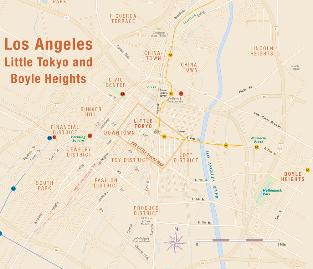 |
This map is
from http://japantownatlas.com/map-losangeles2.html. It
is a map of Downtown Los Angeles, Little Tokyo, and Boyle Heights. This
map not only provides some street names but train routes as well.
Although it
does not show Boyle Heights as descriptive as Little Tokyo or Downtown
Los
Angeles, it shows the proximity between the areas, illustrating how easy
it is to travel throughout Los Angeles. This map is interesting
because of the details it provides about public transportation. I think
that by
providing this information, this map encourages people to take public
transportation.
|
 |
This map is from http://www.studentgroups.ucla.edu/ivgcf/directions.html. It is a fairly simple map to UCLA with only 4 main streets identified. The map has UCLA as a landmark as well as the two main freeways surrounding the school. I think this map is interesting because it highlights the importance of the freeway system in Los Angeles. It assumes that everyone knows about the freeways because of the heavy car influenced culture we live in. Therefore, it emphasizes the freeways and uses them as a reference.
|

Subscribe to:
Comments (Atom)